Validating Machine Learning Models for Geological Information Extraction: Ensuring Accuracy in Geophysical Data Analysis
Xuan-Ce Wang
7/28/20254 min read
The integration of machine learning (ML) techniques into geological and geophysical data analysis has revolutionized how we extract and interpret subsurface information. However, the success of these automated approaches hinges on one critical factor: robust model validation. Without proper validation, even the most sophisticated ML algorithms can produce geologically unreasonable results that mislead exploration efforts and geological understanding.
The Critical Importance of Validation
Machine learning models in geology don't operate in a vacuum—they must produce results that align with established geological principles and known field observations. Unlike traditional statistical applications where accuracy metrics alone might suffice, geological ML models require validation that considers both statistical performance and geological reasonableness. This dual requirement makes validation in geological applications uniquely challenging and essential.
Core Validation Methodologies
Independent Check Areas and Data Splitting
The foundation of ML model validation in geology rests on the principle of independent testing. The most common approach involves splitting available training data into distinct sets: typically two-thirds for model training and one-third for validation. This methodology is particularly effective with supervised learning algorithms like Random Forest, where the model learns patterns from known geological locations and then attempts to predict geology at previously unseen locations.
This approach mirrors the scientific method's emphasis on reproducibility. By testing the model's ability to predict known geology in areas it hasn't been trained on, geologists can assess whether the model has truly learned geological relationships or simply memorized specific locations.
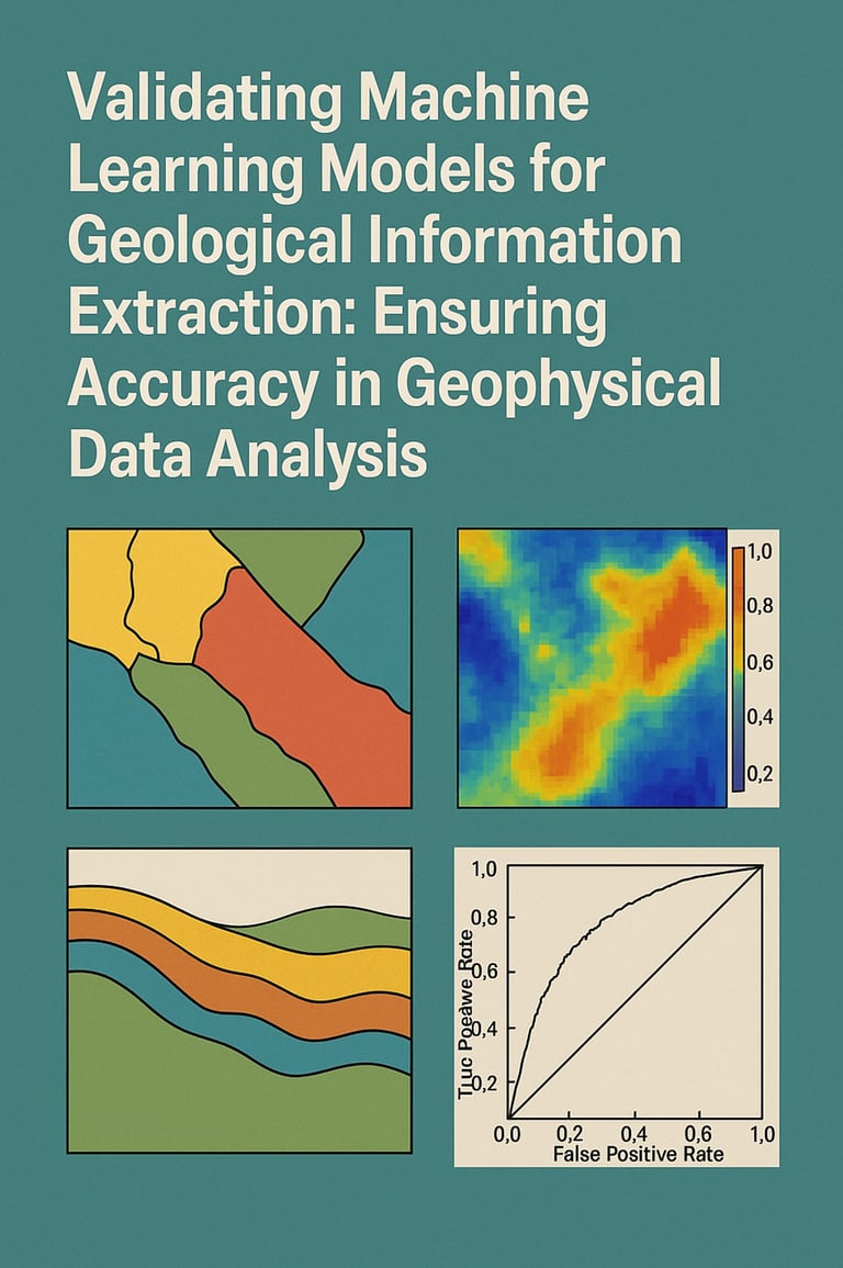
Visual Comparison with Established Geology
One of the most intuitive validation methods involves comparing ML-generated geological maps with existing geological surveys and well-understood areas. This visual comparison serves multiple purposes: it provides immediate feedback on the model's performance, helps identify systematic biases, and reveals areas where the model may be struggling with complex geological relationships.
The Fletcher's Inn case study exemplifies this approach, where machine learning outputs were systematically compared against established geological survey maps, particularly in areas where basement geology was well-exposed and understood. Such comparisons help bridge the gap between automated predictions and expert geological knowledge.
Geological Reasonableness Assessment
Beyond statistical accuracy, geological validation requires evaluating whether the resulting maps make geological sense. This involves examining cross-sections through the predicted geology to ensure they follow established geological principles such as stratigraphic relationships, structural continuity, and logical spatial distributions of rock units.
This assessment often requires experienced geologists to review the ML outputs, applying their understanding of regional geology, structural controls, and depositional environments to evaluate the plausibility of the predicted geological arrangements.
Quantitative Validation Metrics
Classification Accuracy
Quantitative validation provides objective measures of model performance through classification accuracy calculations. These metrics compare predicted geological units or features against known geology in validation areas, typically expressing results as percentage accuracy. Industry standards often consider accuracies above 80% as acceptable, though this threshold may vary depending on the complexity of the geological setting and the intended application.
Probability and Uncertainty Mapping
Modern ML algorithms excel at producing not just predictions but also confidence measures. Probability maps show the strength of relationships between predicted features and target geology, while uncertainty maps highlight areas where the model's confidence is low. These companion maps are invaluable for validation as they help geologists understand where predictions are most reliable and where additional data collection might be needed.
For mineral prospectivity mapping, probability maps are particularly crucial, showing the likelihood of mineralization occurrence across the study area. High-probability zones can then be prioritized for further investigation and ground-truthing.
ROC Curves and Performance Metrics
Receiver Operating Characteristic (ROC) curves provide sophisticated evaluation of model performance, particularly for binary classification problems common in mineral prospectivity mapping. These curves plot the trade-off between true positive and false positive rates, helping geologists optimize decision thresholds for different exploration scenarios.
Prediction Success Evaluation
A specialized validation approach for mineral prospectivity involves plotting the percentage of known occurrences predicted against the percentage of total area classified as prospective. This method directly addresses the practical question: "How effectively does the model identify known deposits within areas it classifies as prospective?"
Field Validation and Ground-Truthing
Perhaps the most critical validation step involves field verification of ML predictions. Traditional field mapping remains the gold standard for confirming geological interpretations, and ML-generated maps should guide rather than replace field investigations.
Field validation serves multiple purposes: it confirms or refutes model predictions, identifies areas where the model performs well or poorly, and provides new data that can be used to refine and improve the model. This creates a feedback loop where field observations enhance model performance, and improved models guide more efficient field programs.
Integration with 3D Modeling
Modern geological interpretation increasingly relies on three-dimensional models that integrate multiple data sources. Validation of 2D ML-generated geological maps often involves incorporating them into 3D modeling software alongside geophysical inversions, drill hole data, and structural interpretations.
This 3D integration provides a powerful validation framework, as geological predictions must remain consistent when extended into three dimensions and combined with independent data sources. Inconsistencies revealed during 3D integration often highlight areas where the ML model needs refinement.
The Iterative Nature of Validation
Validation in geological ML applications is rarely a one-time process. Instead, it forms part of an iterative workflow where initial validation results guide model refinement. If validation reveals systematic issues, geologists may need to:
Refine training data by adding more representative samples
Adjust input parameters or feature selection
Modify model architecture or algorithms
Incorporate additional geological constraints
This iterative approach ensures that the final model not only performs well statistically but also produces geologically reasonable and practically useful results.
Best Practices and Recommendations
Successful validation of geological ML models requires:
Multiple validation approaches: No single validation method is sufficient; combining quantitative metrics, visual comparison, and field verification provides the most robust assessment.
Expert geological input: ML models should complement, not replace, geological expertise. Experienced geologists must be involved throughout the validation process.
Appropriate validation data: Validation datasets should be representative of the geological diversity in the study area and independent of training data.
Documentation and transparency: Validation results, including failures and limitations, should be clearly documented to guide future applications.
Continuous improvement: Validation should inform ongoing model refinement and data collection strategies.
Looking Forward
As machine learning techniques continue to evolve and integrate more deeply into geological workflows, validation methodologies must also advance. Future developments may include more sophisticated uncertainty quantification, automated geological reasonableness checking, and better integration of ML predictions with traditional geological knowledge.
The key to successful geological ML applications lies not in replacing traditional geological methods but in creating robust validation frameworks that ensure automated predictions enhance rather than compromise our geological understanding. Through careful validation, machine learning can fulfill its promise of making geological interpretation more efficient, consistent, and comprehensive while maintaining the geological rigor that underpins sound earth science practice.
This iterative approach to validation ensures that machine learning models in geology serve as powerful tools that enhance rather than replace geological expertise, ultimately leading to better exploration success and improved geological understanding.