Case Study: Unlocking Deep Potential in Mature Orogenic Gold Systems
The Challenge: Seeing Beyond the Drill Bit
1. Superior Resolution with Adjoint Tomography
Unlike standard ray-theory methods, our approach utilizes 2D adjoint tomography based on the membrane wave equation. This accounts for finite-frequency effects, delivering superior imaging accuracy.
Proof of Concept: Forward modeling confirmed our ability to resolve 20m anomaly blocks and detect narrow 10m-wide shear zones, critical for targeting narrow gold-bearing structures.
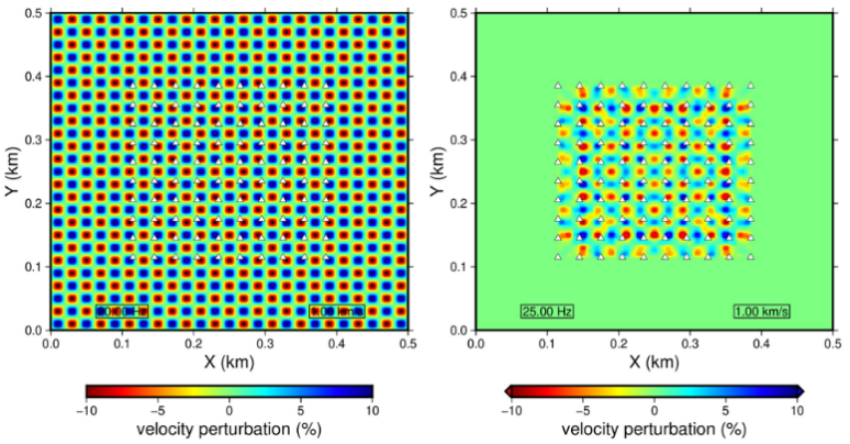
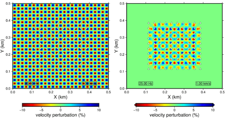
Forward modeling results demonstrating the recovery of 20m velocity anomalies, validating the system's high-resolution capabilities.
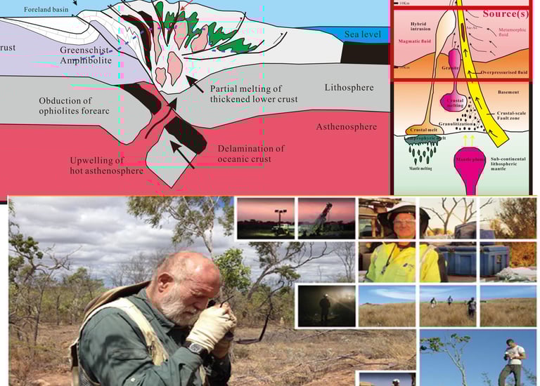
In Western Australia’s prolific Eastern Goldfields, many mature projects face a common hurdle: shallow oxide resources are depleted, and deep mineralization is obscured by thick cover and structural complexity. Traditional exploration relies on grid-based deep diamond drilling—a high-cost, high-risk approach when structural controls are not fully understood.
Our client required a non-invasive, cost-effective method to resolve subsurface structures down to 200m depth and identify high-grade feeder zones before committing to an expensive drilling campaign.
The Solution: Integrated Active & Passive Seismic Imaging
GeoVision AI (LynAI Mines) deployed a cutting-edge geophysical program, integrating Ambient Noise Tomography (ANT) with a proprietary Active Source Enhancement technique.
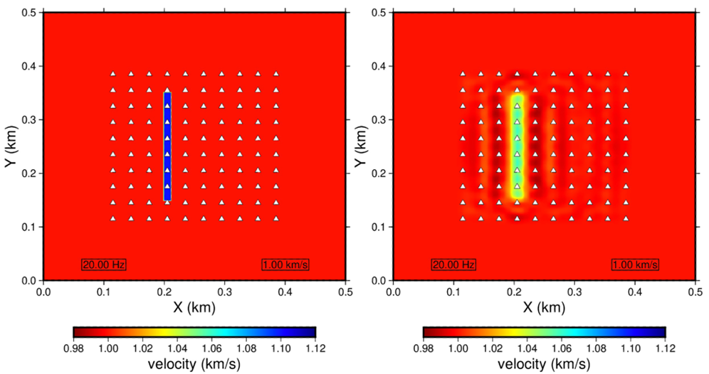
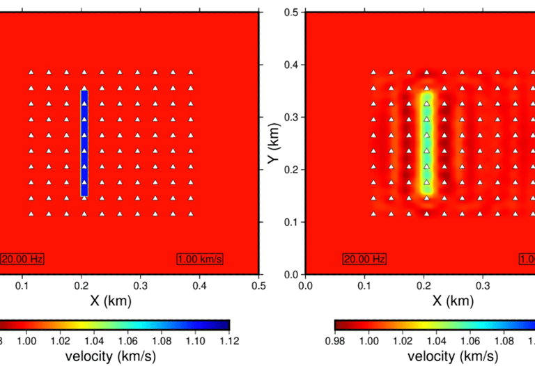
Simulation test successfully identifying a 10m-wide narrow high-velocity zone, simulating a mineralized shear structure.
2. Innovation Spotlight: "Drill-Bit" Active Source
A key innovation in this project was the integration of RC (Reverse Circulation) drilling as an active seismic source.
The Methodology: We utilized the seismic energy generated by the drill bit hammering to supplement ambient noise data.
The Advantage: By applying Double-Difference Travel Time Tomography, we significantly enhanced high-frequency content. This improved resolution in the critical top 100m and eliminated "smearing" artifacts common in traditional passive surveys.
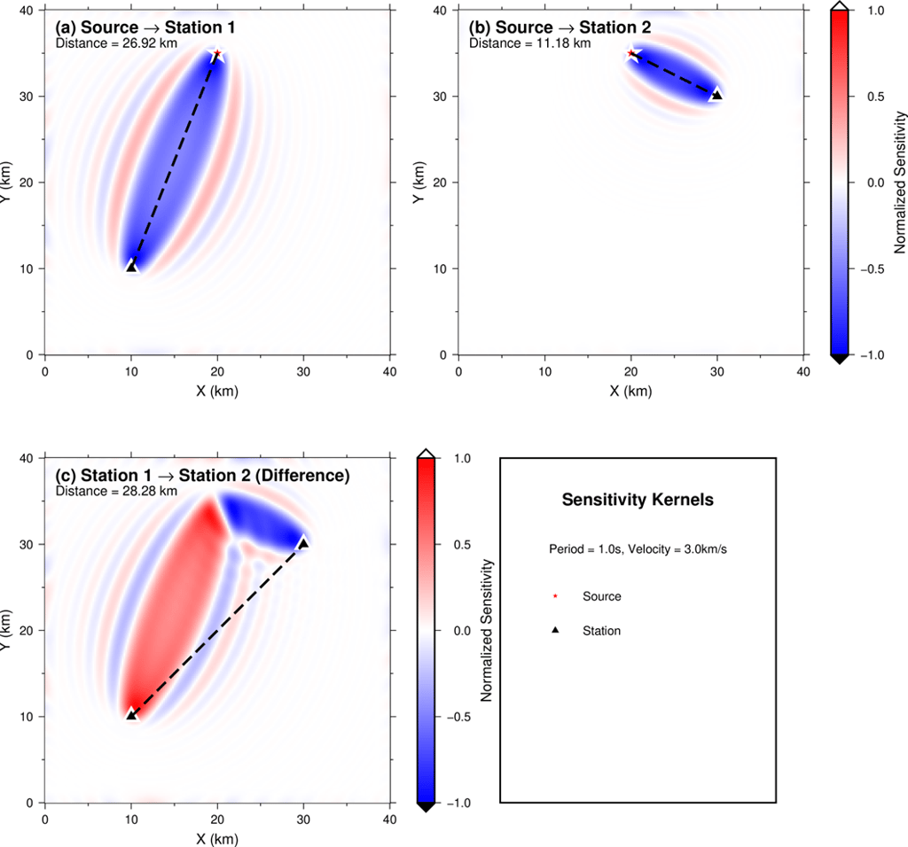
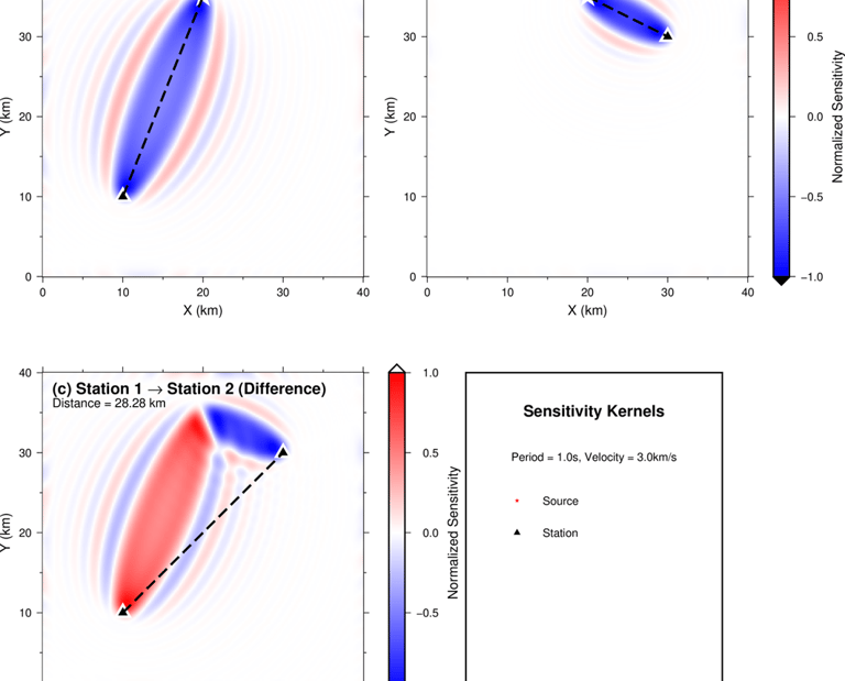
Sensitivity kernels illustrating our proprietary method of using drilling operations (red star) as active seismic sources to enhance array resolution.
3. Precision Field Execution
Data quality is paramount. The survey utilized SmartSolo IGU-16HR 3C sensors deployed with RTK-GPS positioning to ensure <2cm spatial accuracy.
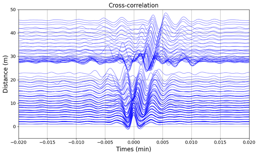
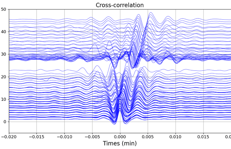
Signal Quality: Cross-correlation analysis revealed clear surface wave signals with high signal-to-noise ratios, providing a robust foundation for velocity modeling.
Subsurface Insights: HVSR (Horizontal-to-Vertical Spectral Ratio) analysis identified distinct dual-peak signatures, potentially indicating subsurface voids or structural disruptions associated with mineralization.

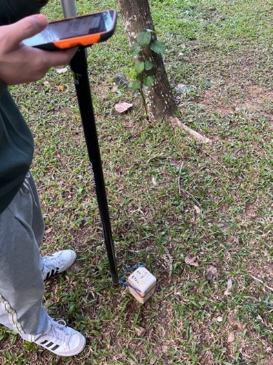
Field technicians deploying sensors using RTK-GPS to ensure centimeter-level positioning accuracy.
Cross-correlation functions showing clear, coherent surface wave signal extraction from ambient background noise.
The Outcome: De-Risking Discovery
This program successfully delivered a high-resolution 3D velocity model that defined structural geometries and alteration zones previously invisible to surface mapping.
Cost Efficiency: The geophysical program provided subsurface definition at approximately 10% of the cost of equivalent drilling information.
Targeting Success: The integration of seismic velocity contrasts with AI-driven lithological predictions allowed the client to prioritize drill targets with significantly higher confidence.
AI Innovations
Transforming mining with AI-driven exploration and production solutions.
AI-Powered Mineral Exploration Revolutionizes Resource Discovery in Western Australia
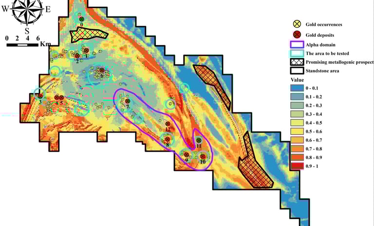
1. Southern Cross Private Gold Project
Achievements: Discovered a gold resource of over 400,000 ounces (NI-43-101 standard) since project initiation in 2018.
Value Creation: Initial investment of AUD 5M, current valuation exceeds AUD 10M, achieving an ROI of over 100%.
Key Highlights: Utilized AI for target selection and field verification, resulting in dual validation methods. Produced two AI-mining research papers currently under revision.
2. Hard Rock Lithium Project in Western Australia
Achievements: Reduced conventional exploration cycle from 4-6 years to just 18 months with AI assistance, improving time efficiency by over 60%. Current market value is AUD 69M.
Innovation Highlights: AI identified undervalued lithium potential in the Pilbara Craton and successfully reclassified a misidentified gold project as a lithium deposit.
Industry Recognition: Recognized for significantly reducing exploration risk and cost, with two academic papers in preparation.
3. Nigeria Nb-Ta-Li Project
Risk Assessment Success: AI model evaluation led to crucial strategic decisions, successfully avoiding potential investment losses.
4. Mineral Rights Assessment Performance
Australian Local Evaluations: Completed 15 mineral rights potential assessments (Au, Li, Cu-Ni), facilitating transactions totalling over AUD 8M.
African Project Evaluations: Evaluated over 30 mineral rights, with a total service value exceeding AUD 10M. Successfully transferred Australian Brownfield training model to African projects.